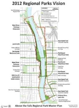
Efforts to redevelop the riverfront on the Upper Mississippi in Minneapolis are set to move forward in the new year, and residents have been asked to offer their feedback. Officials are looking to finalize revisions to the Above the Falls Master Plan, a document meant to guide neighborhood development and parkland enhancements along the Mississippi in North and Northeast Minneapolis. Plan revisions are likely to affect development along the river for decades to come.
Now in a period of public review and comment, the revised plan outlines proposed community and park developments for the east and west banks of the Mississippi River from Plymouth Avenue to the Camden Bridge. Among the projects called for in the plan are expanded parklands, new residential and mixed-use construction, additional biking/walking trails, a swimming/wading beach, and a wetland reclamation project.
The plan also calls for the long-term development of Above the Falls Regional Park, a 226-acre green space extending 2.75 miles on both sides of the river. The park would connect North Mississippi Regional Park and Central Mississippi Riverfront Regional Park, in the Downtown area, creating continuous parkland on the Minneapolis Riverfront. The Above the Falls Regional Park would fill in now-missing links in the Grand Rounds trail system and provide additional connections between North and Northeast Minneapolis.
A fully realized Above the Falls Regional Park is set to potentially take up to 20 years or longer given that much of the riverfront property is now privately owned. Plans call for carefully acquiring additional lands and phasing in projects as is possible. The draft plan accounts for the long-term planning and development likely to be required over the next two decades, while also highlighting “park projects prioritized for implementation in the next several years.”
Among these projects set to move ahead in North Minneapolis are redevelopment of the Upper Harbor Terminal and creation of a Northside Wetlands Park. Owned by the City of Minneapolis, the Upper Harbor Terminal is set to close in 2014. It has been proposed that a significant portion of the 48-acre site be converted into a riverfront park and parkway while the rest of the property is redeveloped for office and industrial purposes that is “park supportive.”
The Northside Wetlands Park, planned for the southern half of the Upper Harbor Terminal site, is now slated to include large gathering places, public water access, and outdoor classrooms similar to those found at North Mississippi Regional Park. The long-term vision for the park will require some land acquisition, and so developments are likely to be staged over time. Current plans suggest that extension of West River Road North is to be among the first steps, which will provide public access to the river. Biking and walking paths are also planned for an early phase of the development.
Among the significant priority projects on the east side of the river is the establishment of a “river beach cove” at the site formerly owned by Scherer Brother Lumber Company, immediately north of the Plymouth Avenue Bridge. Plans call for the restoration of Hall’s Island and creation of an area where park users can swim and wade in the river. Trails are also set to be an important feature of Scherer Park, connecting users to Boom Island as wells as northward parklands.
Among these, immediately to the north, is Sheridan Memorial Park. Currently being developed on the former Grain Belt Brewery site, this area is set to feature a playground for children as well as a memorial to veterans. A continuous public park on the east bank of the river is ultimately envisioned, though acquisition of private land will be required to eventually connect existing recreational areas that include Gluek Park, Edgewater Park, and Marshall Terrace Park.
Community feedback has been influential in decisions on redeveloping the Upper Mississippi riverfront, and residents are encouraged to continue offering their thoughts as initiatives for the area are further shaped. An official 45-day public comment period began on December 10. Individuals can read and provide feedback on the Above the Falls Master Plan Update at the website of the city’s Department of Community Planning and Economic Development (http://www.minneapolismn.gov/cped/projects/cped_above_the_falls). Additional information on the proposed Above the Falls Regional Park can be found at the Minneapolis Park and Recreation Board website (www.minneapolisparks.org/AboveTheFalls).